Nithi Bridge: 7 Shocking Facts About Kenya’s Deadliest Crossing
Nithi Bridge sits on the Embu-Meru highway in Tharaka Nithi County, and it is one of the most feared stretches of road in Kenya. Drivers tense up, passengers say silent prayers, and matatu touts warn travelers the moment the name “Nithi” is mentioned, even when the bridge is still many kilometers away.
This single river crossing has become a national symbol of how road design, history, and human tragedy can collide. In this article, we will walk through the full story of Nithi Bridge: how it was built, why it became so dangerous, the major accidents that shaped its grim reputation, and what is being done to finally fix it.
Where Is Nithi Bridge Located?
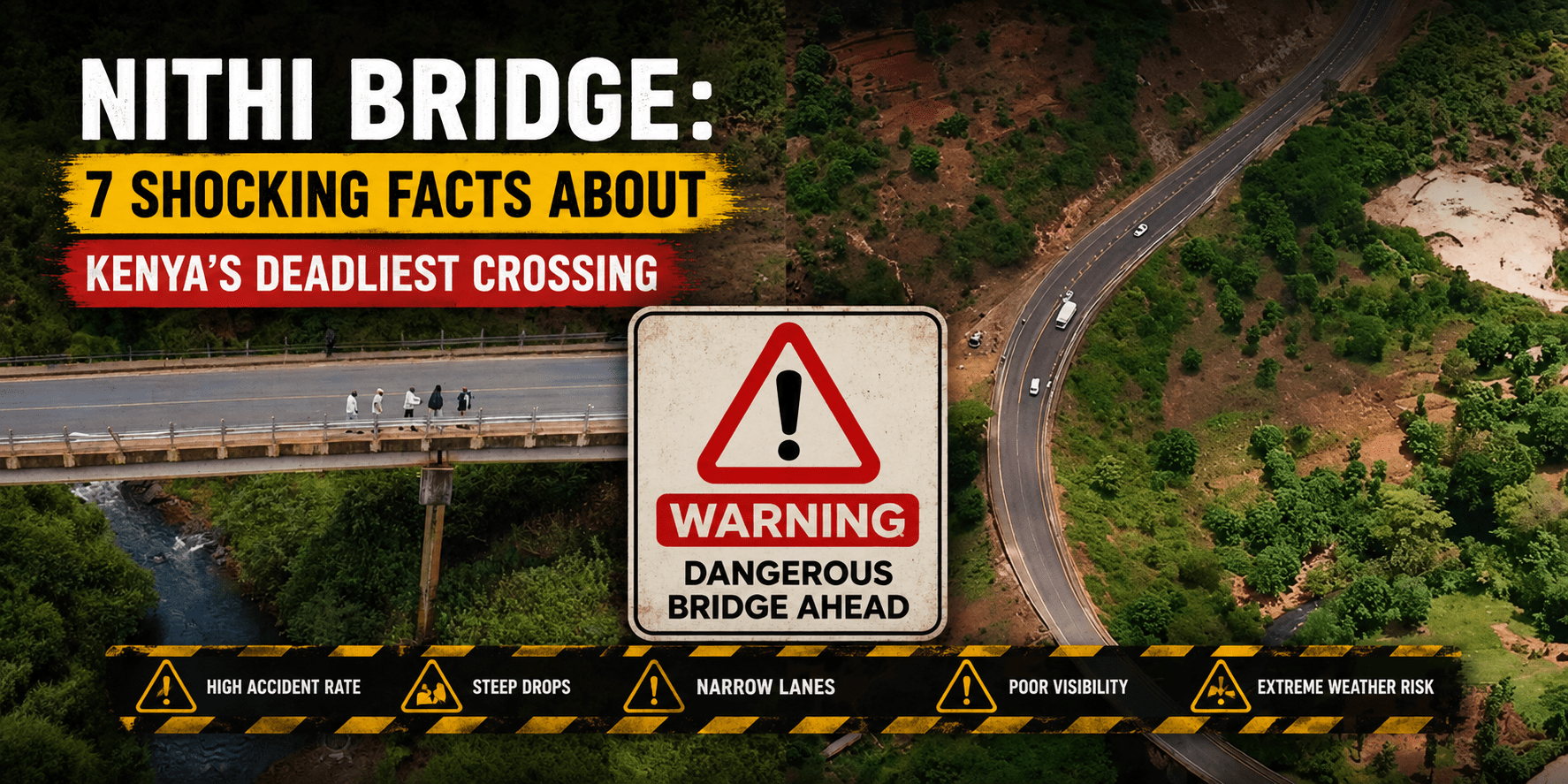
Nithi Bridge crosses the Nithi River along the B6 Embu-Meru-Isiolo highway, between the towns of Chogoria and Chuka in Tharaka Nithi County. It sits roughly seven kilometers from Chuka town, deep in the foothills below Mount Kenya.
The location alone tells part of the story. The bridge sits at the base of a steep, winding descent, with the road curving sharply just before the crossing. Vehicles coming from the Meru side pick up speed on the slope, and many drivers struggle to control that momentum by the time they reach the bend at the bottom.
For hikers and tourists, the area is also the gateway to the Chogoria Route up Mount Kenya, considered by many to be the most scenic of all the trails to Point Lenana. So the same river valley that has caused so much heartbreak on the road is also home to breathtaking highland scenery just a short distance away.
The Surprising History Behind Nithi Bridge
Few people realize that a war fought thousands of kilometers away in the South Atlantic helped shape the design of Nithi Bridge. The Thuci-Nkubu road, which the bridge is part of, was built in the early 1980s by Kier International and financed through a British government grant.
According to the late project engineer Ernest William Twell, the original plan was far gentler. The road was meant to loop through old Mitheru market, ascend gradually toward Marima, pass through Chogoria town, and connect to the highway near Nkubu township through Igoji and Kanyakine.
Then, in 1982, Britain entered the Falklands War against Argentina. The unexpected conflict tightened British government spending, and because the Kenyan road project depended on a British grant, the budget was suddenly squeezed. Contractors were forced to cut more than ten kilometers from the planned route, eliminating the gentle loop and replacing it with a direct, steep descent at Mitheru toward Marima.
That single cost-cutting decision created the dangerous slope and sharp bend that travelers now associate with Nithi Bridge. The road was finally commissioned in 1985, and the Duke of Edinburgh, Prince Philip, cut the ribbon at a monument near the Thuci River, since Queen Elizabeth II’s planned visit did not materialize.
What should have been a routine infrastructure milestone instead set the stage for nearly four decades of tragedy.
Why Nithi Bridge Became So Dangerous
Several factors combine to make Nithi Bridge one of Kenya’s most notorious road accident black spots.
A steep, winding descent. Vehicles approaching from Meru pick up speed on a long downhill stretch before reaching a sharp curve right at the bridge itself. Drivers who misjudge their speed or whose brakes fail have very little room to recover.
A blind, narrow crossing. The bridge sits around a bend on steep slopes, which limits visibility for oncoming traffic and makes overtaking extremely risky.
Heavy long-distance traffic. The B6 highway carries buses and trucks traveling between Meru, Nairobi, Mombasa, and the wider eastern region, meaning large, heavily loaded vehicles regularly attempt the descent.
Weather and river conditions. During the rainy season, the Nithi River swells, and the road surface becomes slippery, increasing the risk of vehicles sliding off the carriageway.
Aging design standards. The road was engineered to follow the natural contours of the land with minimal disruption to the environment, a common British road-building philosophy of the era. While that approach reduced environmental damage, it also produced a steeper and more hazardous gradient than modern safety standards would allow.
Local rescue teams have long described the cone-shaped speed bumps installed on the Meru-side approach as a constant, unsettling reminder to motorists of what lies ahead.
Major Accidents at Nithi Bridge Over the Years
The scale of loss at Nithi Bridge is difficult to comprehend. Since the road’s commissioning in 1985, the crossing has remained, in the words of local officials, a notorious black spot that continues to haunt travelers.
1995: A matatu plunged roughly 40 feet into the river, killing 16 people, including 12 members of a single family.
1998: A Stagecoach Kenya bus carrying more than 100 passengers plunged into the river, killing 56 people on the spot. The disaster was severe enough that the company halted its operations on the route afterward.
1999: A bus collided with a matatu near the bridge, killing another 16 passengers.
August 25, 2000: A Tawfiq bus traveling from Maua to Mombasa, officially rated for 65 passengers but carrying more than 80 at the time, plunged into the Nithi River, killing at least 45 people. Another 27 survivors were rushed to Chogoria Mission Hospital. International media reported that the tragedy brought the bridge’s five-year death toll to at least 158 people.
August 2020: A multiple-vehicle accident killed one person and injured nine others after a Tharaka Nithi County fire engine lost control while responding to an earlier crash involving a motorcycle rider.
July 24, 2022: A Modern Coast bus heading toward Mombasa collided with a Nissan X-Trail and fell off the bridge into the river, roughly 40 meters below, killing 34 people in what many described as a chilling repeat of the 2000 catastrophe.
Early 2024: Another tragic head-on collision between a Nairobi-bound Toyota Hiace and a Meru-bound Toyota Hilux claimed 12 lives, including two children.
April 2024: A Kensilver minibus lost control descending the slope, killing four people and injuring several others.
October 2025: A lorry transporting bananas and food produce from Imenti lost control and plunged into the river, killing two people, with rescuers struggling to retrieve one body trapped in the wreckage.
Police commanders have repeatedly noted that mechanical failure, combined with the steep approach, is a recurring factor in these crashes. Taken together, the death toll at Nithi Bridge over the past four decades is estimated to be in the hundreds.
Government Promises to Fix Nithi Bridge
For years, Kenyan leaders have promised to redesign or reconstruct Nithi Bridge to eliminate the deadly bend and slope. President William Ruto pledged that funds had been set aside to redesign the crossing, stating that the goal was to straighten the bridge so it would stop being what he called a trap that claims citizens’ lives.
Following the October 2025 lorry accident, Interior Cabinet Secretary Prof Kithure Kindiki, speaking in Chogoria near the bridge, said reconstruction would begin within months.
It is worth noting that reconstruction efforts following the catastrophic 2000 accident did lead to a climbing lane being added on the Marima descent, intended to give heavy vehicles more room to slow down safely. Even so, residents and transport operators argue that a full redesign of the bend and slope, not just incremental fixes, is the only lasting solution.
The Natural Beauty Surrounding Nithi Bridge
It would be unfair to describe Nithi Bridge only through the lens of tragedy. The river valley around the crossing is part of one of the most beautiful regions in Kenya, nestled in the lush, well-watered slopes below Mount Kenya.
Just upstream, hikers following the famous Chogoria Route pass spectacular natural landmarks fed by the same river system, including Nithi Falls, Lake Michaelson, Vivienne Falls, and the dramatic Gorges Valley. Many mountaineering guides consider the Chogoria Route the most scenic approach to Point Lenana, offering diverse landscapes and far fewer crowds than the popular Sirimon or Naro Moru trails.
Nearby Chogoria town is also home to PCEA Chogoria, a mission station established in 1922 that grew into one of the most significant centers of education, healthcare, and community development in the wider Meru and Tharaka Nithi region.
This contrast, a stretch of road infamous for tragedy sitting minutes away from some of Kenya’s most stunning highland scenery, is part of what makes the Nithi Bridge story so striking.
What Engineers Say Needs to Change
Civil engineers and road safety experts who have studied the Nithi Bridge black spot generally point to the same core issues: gradient, alignment, and structural capacity.
A modern fix would likely involve re-aligning the approach roads to reduce the steepness of the descent, widening the bridge deck to improve visibility and overtaking safety, reinforcing the structure to handle modern traffic loads, and installing better drainage to manage runoff during the rainy season when the Nithi River swells.
Guardrails, improved signage, and rumble strips can help in the short term, but engineers generally agree that only a full geometric redesign of the road, not just cosmetic upgrades to the bridge itself, will meaningfully reduce the accident rate at this location.
This is where thoughtful, well-executed civil engineering and construction work becomes essential. Roads and bridges built decades ago under different budgets, technologies, and safety standards need to be re-evaluated with the benefit of modern engineering practices, proper soil and gradient analysis, and durable construction materials.
Lessons Nithi Bridge Teaches Kenya About Road Safety
The story of Nithi Bridge offers several important lessons for infrastructure planning across Kenya.
First, short-term budget decisions can create long-term safety hazards. The cost cuts forced by the Falklands War in the early 1980s reshaped the road’s alignment in a way that has cost hundreds of lives over the following four decades.
Second, road design must account for real-world driving behavior, not just theoretical traffic flow. A steep descent followed immediately by a sharp bend will always be dangerous, regardless of how many warning signs are installed.
Third, reactive fixes are not enough. Speed bumps, signage, and climbing lanes have helped at the margins, but the underlying geometry of the road remains the central problem.
Finally, sustained public pressure matters. It is largely because communities, journalists, and local leaders have continued to highlight the human cost of Nithi Bridge that successive governments have been forced to keep reconstruction on the national agenda.
Final Thoughts on Nithi Bridge
Nithi Bridge is more than a dangerous river crossing. It is a case study in how engineering decisions made decades ago continue to shape outcomes today, for better or worse. Its history, shaped by a distant war, its decades of tragedy, and the surrounding beauty of the Mount Kenya foothills together tell a story that is uniquely Kenyan.
As reconstruction plans move forward, the hope shared by residents, transport operators, and engineers alike is simple: that the next chapter of the Nithi Bridge story will finally be about safety, rather than sorrow.
Building Safer Infrastructure for Kenya
Stories like Nithi Bridge are a powerful reminder of why sound civil engineering and quality construction matter, especially on roads, bridges, and slopes where lives are on the line every single day.
Jowach Construction Ltd specializes in general housing construction and planning, delivering well-engineered, durable homes built to last across Kenya’s varied terrain and climate. If you are planning a residential construction project and want the same careful, safety-first approach to engineering that roads and bridges like Nithi Bridge deserve, get in touch with the team.
📞 +254 704 264 302 🌐 Jowach Construction Ltd